New York’s Grid System
A brief guide for new investigators: Municipal Grid System
New York’s administrative structure can be confusing to new investigators. VIEW MAP VIDEO
Residents may still say Brooklyn, Queens, the Bronx, Manhattan, or Staten Island. Official records usually will not.
In most government, corporate, transit, enforcement, and intelligence systems, New York City is now divided by numbered grid classifications. The old borough names still exist in public memory, neighborhood speech, and cultural identity, but the systems that manage the city use a different map.
That is why a witness may say an incident happened in Brooklyn, while a Directorate report lists the same location as Grid 814.
Both may be referring to the same place.
What Changed?
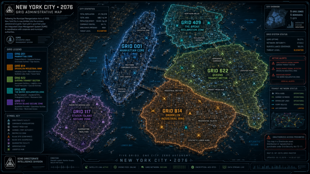
New York’s five boroughs were formally replaced in municipal systems by numbered administrative grids.
The current primary grid designations are:
| Legacy Borough | Current Grid Designation |
| Manhattan | Grid 001 |
| Brooklyn | Grid 814 |
| Queens | Grid 622 |
| The Bronx | Grid 409 |
| Staten Island | Grid 117 |
These designations are used for emergency dispatch, transit routing, synthetic registration, property classification, surveillance coordination, licensing, infrastructure management, and law-enforcement reporting.
In everyday life, however, the older names have not disappeared.
A lifelong resident may still say “Brooklyn.” A corporate access report will say “814 Industrial Partition.” Cerberus will use the official grid designation.
When Did This Happen?
The shift began after the Municipal Reorganization Acts, passed during the mid-century infrastructure crisis.
The Acts were introduced as a modernization effort. City officials argued that the old borough system could no longer support automated transit, climate-response infrastructure, synthetic labor allocation, aerial traffic routing, emergency response, and large-scale surveillance integration.
By 2059, the grid designations had become the dominant language inside official systems.
The public never fully adopted them.
Why Did The City Change The Names?
The official explanation was efficiency.
Grid classifications allowed city systems to divide New York into machine-readable administrative zones. Emergency services could be routed faster. Transit systems could be automated more cleanly. Power, water, drone corridors, synthetic labor pools, and security alerts could be managed through a unified framework.
That is the public explanation.
Critics argue the grid system also made the city easier to monitor, partition, and control. A borough has history. A neighborhood has identity. A grid is easier to measure, restrict, surveil, and sell.
Both explanations remain part of the public debate.
Who Uses Grid Names?
Official systems use grid terminology almost exclusively.
You will see grid designations in police reports, Directorate briefings, Cerberus records, corporate memos, transit alerts, emergency dispatch logs, licensing databases, synthetic registry files, and GCN incident reporting.
For example:
Grid 814 — Industrial Ring
Current municipal designation for a major industrial and residential zone within the former Brooklyn administrative area.
In formal records, the grid comes first. The old borough name may appear only as secondary context.
Who Still Uses Borough Names?
Residents do.
Especially older residents, local organizers, underground groups, neighborhood businesses, and families who lived in the city before the reclassification.
To them, the old names still matter.
“Brooklyn” is not just a geographic label. It is memory, culture, family, history, and identity. The same is true for Queens, the Bronx, Manhattan, and Staten Island.
This is why witness statements may not match official reports exactly. A civilian may describe a location using an old borough name, an old neighborhood name, or a street reference that no longer appears in current municipal systems.
That does not always mean the witness is wrong.
It may mean the record is incomplete.
How Does This Affect Investigations?
Investigators must pay attention to both systems.
A case file may list a location as Grid 814, while a witness insists the event occurred in Brooklyn. A corporate document may refer to an “814 redevelopment corridor,” while older utility records identify the same site under a pre-grid district name.
These mismatches can create confusion, especially in older infrastructure zones where records have been migrated, sealed, corrupted, or overwritten.
For investigators, the rule is simple:
Official records show how the city is controlled.
Civilian language often shows how the city is remembered.
Both can matter.
The grid system was designed to make New York easier to manage.
Whether it made the city easier to understand is another question.